10. Pedestal Rocks Loop to King’s Bluff Loop
4-mile loop in Pedestal Rocks Scenic Area, Ozark-St. Francis National Forests, AK
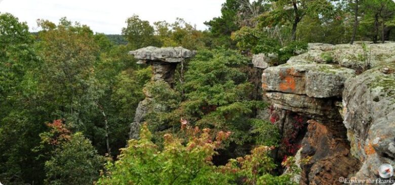
Hike to far-reaching views, as well as up-close vantages of arches, overhangs, rock houses, waterfalls, and this trail’s eponymous Pedestal Rocks. Leave the AR 16 trailhead on the first of two circuits, taking the Pedestal Rocks Loop past Arch Rock before arriving at a bluff line that offers sweeping panoramas and closer looks into the fissured rock face below.
source:exploretheozarksonline.com
The Pedestal Rocks then appear, jutting up from the earth’s floor like massive columns to support rocky overhangs. Next, take the King’s Bluff Loop, which delivers endless views of the surrounding landscape. Pass a small waterfall before reaching the actual King’s Bluff, a basketball-court-sized rock slab overlooking a creek.
Another waterfall drops over a rock rim at King’s Bluff. Beyond King’s Bluff, the trail returns through woods to the trailhead, completing the four-mile hike.
9. The Cathedral of Palms
6.2-mile loop in St. Marks National Wildlife Refuge, FL
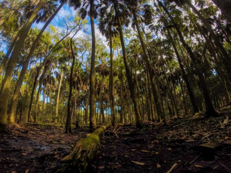
This picturesque trek takes place at St. Marks National Wildlife Refuge, where the Florida Trail meanders through a tall palm forest known as the Cathedral, so called because the interwoven palm fronds have grown together to roof a gorgeous slice of the Big Bend near Tallahassee.
You can lose hours here in quiet contemplation, but this hike also visits Shepherd Spring before completing the 6.2-mile loop. The first few miles are easy, tracing closed refuge roads through woods ranging from turkey oaks to bay/gum swamps to longleaf/wiregrass hills, eventually entering the Cathedral as a single-track trail.
source:visittallahassee.com
Walk through a moist woodland that comprises maples, cypresses, magnolias, and live oaks, using boardwalks in the wettest locales. A spur trail leads left to massive Shepherd Spring. The vivid blue pool here stretches wider than a house, and you can see fish floating motionless above vents.
Alligators may be sunning in the margins. Beyond the spring, enter low, scenic, and sometimes wet woods, rife with beard cane. Rise to high-and-dry pine country, completing the loop.
8. Improved Trail to Primitive Trail
4.8-mile loop in Clark Creek Natural Area, MS
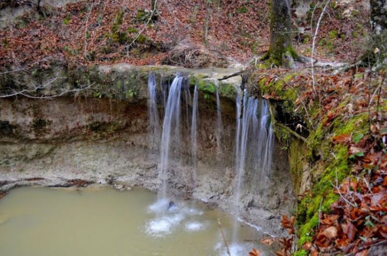
Pristine Clark Creek and its tributaries offer more than 50 waterfalls and state-champion old-growth trees. Make a 4.8-mile loop through the natural area, traveling incredibly steep trails past some of these waterfalls and along spindly ridges and astride clear sandy streams — the land and waters never stay level for long here.
There’s even a view or two from atop the ridges, located in the Tunica Hills just east of the Mississippi River. First, follow the Improved Trail, where precipitous ravines drop from the ridge. Pass sheer bluffs and crystalline waterfalls cutting valleys amid ferns, saw palmetto, vines, and a riot of vegetation.
source:waterfallrecord.com
A stilled hiker will hear waterfalls from hilltops amid a symphony of birdsong. The vast majority of cascades here are either completely off-trail or accessed via unmaintained, user-created paths that can be slippery and treacherous. Then join the Primitive Trail.
At 3.8 miles, reach the father of all trailside waterfalls at Clark Creek Natural Area. It drops 30 feet over a rock lip into a half-cathedral where scattered rocks and gravel lie below. Climb hand over fist — your average Clark Creek lung-buster climb — back to the trailhead.
7. Blue Spring Loop
6.1-mile circuit in Conecuh National Forest, AL
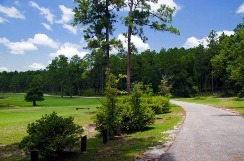
Blue Spring is your prize on this 6.1-mile circuit in southern Alabama, where ecotones change with the hilly terrain. One minute you are in high pines and the next you are skirting blackwater streams, swamps, and ponds. The trek leaves Conecuh National Forest’s Open Pond for Buck Pond and Ditch Pond, rimmed in tawny grasses.
The water levels of these natural ponds rise and fall with the rains. Ahead, well-spaced longleaf pines and turkey oaks crown the hilltops. Swampy terrain border creeks and bay trees line the main channels, while tupelo trees stand silent in still waters.
source:alabamabirdingtrails.com
The environments overlap one another, forming a mosaic of biodiversity. Surmount hill country and then drop to fast-flowing, sand-bottomed Five Runs Creek, mitigated by numerous fallen trees. Join noisy Pond Creek to reach Blue Spring.
The azure pool and spring vent are encircled by woods, except for the crystalline outflow stream. Your return route rises into pine-clad hills. Circle Alligator Hole, as much marsh as pond, with fallen tree trunks, grasses, beavers, and alligators. Bridge the outflow of Alligator Hole and then backtrack to the trailhead.
6. Sitton Gulch to Lower Falls to Daniel Creek
4.8-mile loop in Cloudland Canyon State Park, GA
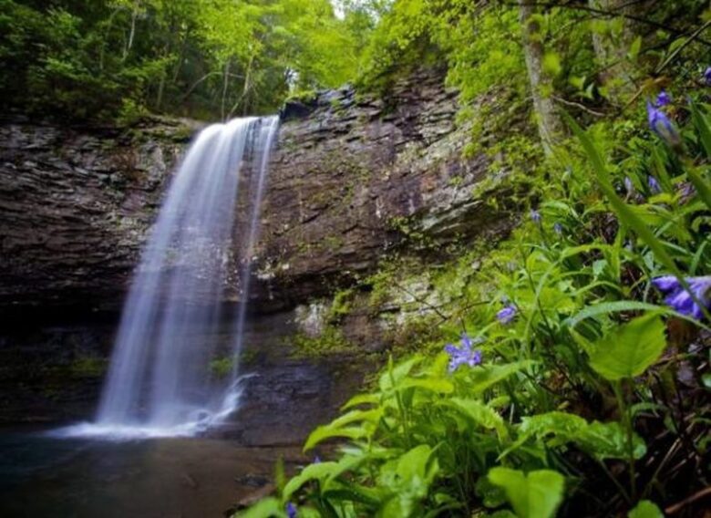
Take a 4.8-mile loop at Cloudland Canyon State Park, trekking a rock-rimmed gorge with sheer walls, cliff lines, waterfalls, and vistas. Leave the park picnic area along the canyon rim, with near-instant views. Make a side trip into Sitton Gulch, where two waterfalls drop.
Descend a near-vertical bluff, reaching Upper Falls, with a large plunge pool. Make Lower Falls via an engineering marvel of a path involving untold steps. Next, cross Daniel Creek among mountain laurel and rhododendron tangles in Sitton Gulch.
source:gastateparks.reserveamerica.com
Then, climb the canyon’s west rim, where panoramas open from wide rock slabs. Ramble through thickets of Table Mountain pines broken by big boulders to reach a fantastic overlook at mile 2.6, taking in views of Lookout Valley and beyond to the Tennessee River to the north.
The west brow of Lookout Mountain stretches northeast. Then, as you head into Sitton Gulch, the canyon narrows. The far rim’s rock walls reveal their impressive geological detail. A second developed overlook discloses a tributary cutting its own gorge to meet Daniel Creek.
Still another overlook exposes a view across the canyon. Return to Daniel Creek, and then ascend to the picnic area.
5. The Boardwalk and Oak Ridge Trail to Kingsnake Trail
6.5-mile loop in Congaree National Park, SC
According to Nicky Smith of the Home Care Choices, Congaree National Park is known as the “Redwood Forest of the East” for its huge trees and the highest continuous forest canopy on earth. An extensive trail system includes a very long (and presumably costly) boardwalk that makes a 2.4-mile loop itself!
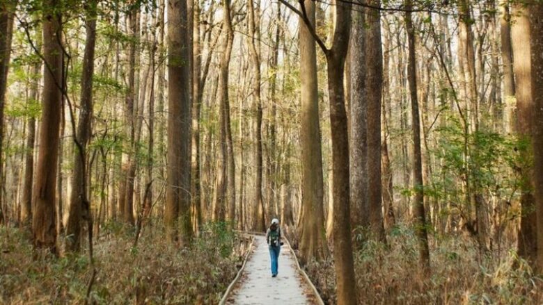
For a great 6.5-mile loop that includes part of the boardwalk, join the boardwalk at the visitor center, walking eye-level with wide, buttressed, moss-covered cypress and tupelo trees in a wetland periodically inundated from the overflowing Congaree River.
source:nps.gov
Shortly, keep forward on the Weston Lake Loop Trail to discover gorgeous Cedar Creek, a dark-water stream. Pick up the Oak Ridge Trail amid huge primordial hardwoods towering above silent sloughs in the back of beyond. Walk in the shadow of more giant trees.
Don’t be surprised if you see wild boar or deer — both are common here among the centuries-old white oaks and loblolly pines. Briefly join the Kingsnake Trail and then pick up Weston Lake Loop Trail again just after bridging Cedar Creek for the second time.
Ahead, cypress trees, with their knees rising upward from the uneven wetland floor, stand as sentinels over Weston Lake. Take the Elevated Boardwalk back to the visitor center. It lends an uncommon perspective of the parkland as you hike ten feet above the forest floor.
4. Shuckstack Fire Tower
11-mile circuit in Great Smoky Mountains National Park, NC
Unnamed waterfalls, a named cascade, and stupendous 360-degree views are the highlights of this 11-mile there-and-back trek through perennially popular Great Smoky Mountains National Park.
Take the Twentymile Trail as it traces Twentymile Creek, with waterfalls divided by deep pools harboring lively rainbow trout. Come to Twentymile Cascades, a cataract that plunges 40 feet in stairstep fashion over wide stone ledges.
Continue mimicking the curves and gradient of Twentymile Creek, eventually reaching Proctor Field Gap. Twentymile Trail rises into xeric woods of oak, mountain laurel, pines, and sourwood, adding some vegetational variety as you gain elevation.
source:romanticasheville.com
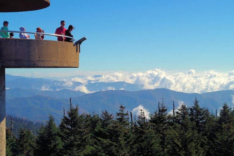
A final series of switchbacks leads to the Appalachian Trail and Sassafras Gap at mile 5.1. Turn southbound on the Appalachian Trail. A spur path rises up craggy Shuckstack peak and a fire tower, elevation 4,020 feet. Atop the tower, views extend in every direction.
The main crest of the Smokies stands proud. Fontana Lake covers the flooded valley of the Little Tennessee River. The rampart of Gregory Bald fills the horizon. Your route up the Twentymile Creek Valley lies below.
Waves of mountains extend into Nantahala National Forest. From this vantage point, the surrounding Southern Appalachians look especially rugged.
3. Honey Creek Loop
5.1-mile loop in Big South Fork National River and Recreation Area, TN
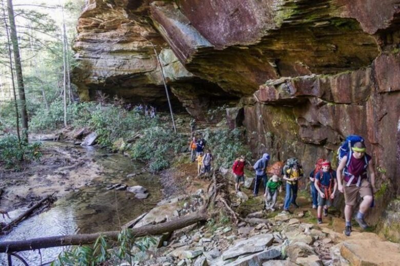
Scramble through boulder mazes, over slick rocks, up and down steep slopes, and into stream gorges to discover overhanging cliffs, waterfalls, rock houses, boulder gardens, and a first-rate vista on the 5.1-mile Honey Creek Loop.
First, reach Honey Creek Falls, descending a ledge into a dark, cliff-enclosed pool. Next comes Ice Castle Falls, a curtain drop spilling 40 feet over an overhanging rock house. Make the first of several scrambles leading into dark crevices between giant boulders.
source:rootsrated.com
Turn up North Honey Creek, a place of continuous beauty and challenging terrain. A cavernous rock house rises across the creek, with a ladder that leads to an elevated room where you slither through a hole into an adjacent rock house.
Cruise along fortress-like sandstone bluffs above the Big South Fork River. Make Honey Creek Overlook using multiple metal ladders to reach a superlative vantage of the Big South Fork Valley, and then travel along more magnificent bluffs and rock houses.
Work up an unassuming wooded valley that contrasts with the mayhem of Honey Creek. It shortly drops you out on the trailhead.
2. Freeman Trail to Byron Reece Trail to Blood Mountain
5.8-mile loop in Blood Mountain Wilderness Area, GA
This stretch of the Appalachian Trail takes you to stunning vistas from open rock faces framed by stunted trees atop Blood Mountain, one of Georgia’s legendary peaks. From Blood’s crest, make a 5.8-mile loop using the Freeman Trail, with its own views and generally rugged nature, all within the Blood Mountain Wilderness.
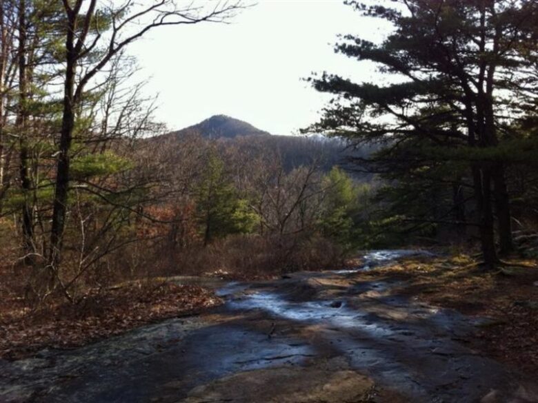
From a parking area below Neels Gap, take the Byron Reece Trail, passing a waterfall on Shanty Branch. Meet the AT and head southbound to reach your first of many vistas. Open rock slabs bordered by Virginia pines lead to the mountain crest and a grand overlook where waves of mountains march across the horizon.
source:rootsrated.com
Weave in and out of a stunted oak, pine, and mountain laurel forest, reaching the tip-top of Blood Mountain, elevation 4,461 feet, at two miles. Pass the historic Blood Mountain shelter, built in the 1930s, and Picnic Rock, with another vista. Descend to Bird Gap and the Freeman Trail at mile 3.3.
Hike in sporadic tree cover that allows views to the south. More vistas open where the boulder-strewn Freeman Trail crosses rock faces similar to the ones higher up on Blood Mountain. Hop a few rocky rills before completing the loop.
1. Raven Cliff Falls to Matthews Creek Valley to Foothills Trail
7.9-mile circuit in Caesars Head State Park, SC
This challenging day hike in the Mountain Bridge Wilderness leads to an overlook of 400-foot Raven Cliff Falls before looping deep into the hardwood forest for yet more hidden waterfall action.
Ramble into the high country to reach the first vista of Raven Cliff Falls, absorbing the entirety of the colossal cataract pouring over a sheer rock face. Next, descend into remote Matthews Creek Valley, where big rocks, frothing water, and yawning pools cut a helluva gorge.

source:rootsrated.com
Double steel cables tightly strung across the creek create a high-water, high-wire-act creek crossing. The climb from the stream uses ladders and steps to gain ground. Emerge onto an outcrop and a rousing view of upper Matthews Creek and the mountains beyond, on which you will shortly be walking.
Below, Raven Cliff Falls roars. Be careful: The drop is a doozy. Meet Matthews Creek again at an incredible suspension bridge that stands above the uppermost cataract of Raven Cliff Falls. Downstream, the main drop of Raven Cliff Falls disappears over a rock rim.
After getting your fill of Matthews Creek’s superlative beauty, join South Carolina’s main mountain track, the Foothills Trail, for more highland rambling to complete the loop.

